


On Wednesday (Aug 26) morning, catastrophic flash floods and landslides tore through the Nepal-Tibet border region.
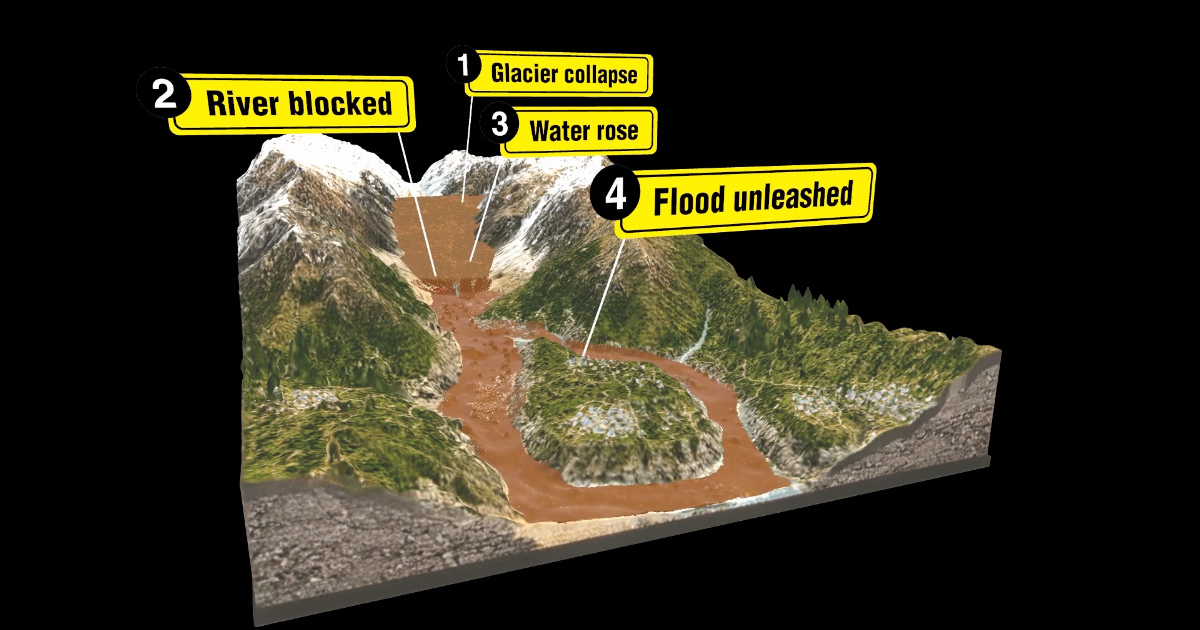
The disaster started in the high-altitude peaks of the Himalayas, where a devastating avalanche of ice, rock, mud and water smashed into villages and a border port.
At least 500 people have died, and nearly 2,000 are still missing, including hundreds of tourists and pilgrims from around the world.
Entire villages were wiped out in seconds. Roads, bridges and power stations were destroyed as a torrent of water, ice, mud and rock surged through the Himalayan valleys.
The terrifying force flattened buildings and swept away vehicles in its path. Multiple videos captured the moments when entire locations were transformed in mere seconds.
Surveillance cameras mounted at Gyirong Port caught the moment the disaster unfolded, showing a massive, brownish mudflow surging down the canyon from the Nepali side of the border, directly engulfing the Gyirong Port building and people attempting to escape.
Satellite images of the region also show just how much the rivers’ borders had expanded.
So what caused it?
The disaster appears to have begun high on the north side of Langtang Lirung, a mountain in Nepal near the border with Tibet.
And while the disaster was earlier thought to be caused by a 4.4-magnitude earthquake, subsequent analysis by the United States Geological Survey found that the seismic energy had instead been generated by the collapse and resulting debris flow.
Could there have been more warning?
Many conventional flood-warning systems rely heavily on rainfall, but there was no significant rainfall immediately before this disaster.
Hatim Sharif, a hydrologist at the University of Texas San Antonio, told AFP that the lack of rainfall beforehand would have undermined conventional flood-warning systems.
By the time the torrent was moving through the narrow Himalayan valleys, there was very little time to escape.
The satellite images below of Syapru Besi in Nepal before and after the flooding show the extent of how much the river overflowed.
The extreme topography of the Himalayas made matters worse. Steep slopes accelerated the material downhill, while narrow valleys channelled the flow towards settlements below.
Was it caused by climate change?
But as to what led to the collapse in the first place, much remains unclear for now. Scientists say it is too early to blame climate change directly, but warming temperatures could be making the Himalayan landscape less stable.
University of Dayton geosciences professor Umesh Haritashya said frozen water in cracks within the mountains can act as a “glue” that helps hold rocks and soil together.
“As the climate changes, as the weather gets warmer, the glue is melting,” he told CNA’s Asia First.
Is the danger over?
The spectre of further tragedy remains. Authorities have warned of fresh flooding from dammed lakes upstream of the disaster sites.
Debris from the disaster has blocked the Bhote Koshi River, forming a new lake. Water is building up behind the new barrier, and there is a high risk that it could breach, sending a new surge of water downstream.
On Aug 28, rescue operations in Nepal and Tibet were briefly halted after an upstream dammed lake started overflowing. Rescue efforts resumed later in the day.
Continued overflow could trigger another flash flood or mudslide, making it extremely dangerous for rescuers to proceed towards the priority search area.
For the nearly 2,000 still missing, rescue teams are racing to find them, even as the risk of another disaster looms.

