


Since the United States and Israel launched attacks on Iran 100 days ago, the full scale of destruction across the region has been difficult to assess.
Satellite imagery companies, including Planet Labs – the world’s largest commercial satellite operator based in California – have placed an indefinite blackout on pictures of the conflict at Washington’s request.
But before the restrictions took hold, cameras in space from Airbus, Planet Labs, Sentinel and Vantor captured a sweeping picture of the devastation.
Al Jazeera’s Open Source Unit has compiled 15 sites from Iran, Lebanon and across the Gulf that show what this war has looked like from above.
Sites across Iran
The Natanz complex in Isfahan province, Iran’s largest uranium enrichment facility, was struck twice in June 2025, first by Israel, then by the US as part of Operation Midnight Hammer, using GBU-57 bunker buster bombs alongside strikes on Fordow and Isfahan.
Before-and-after satellite images taken in early March show direct structural damage to buildings, ramps, and entrance pathways for personnel and vehicles leading to the underground enrichment halls following joint US-Israeli air attacks.
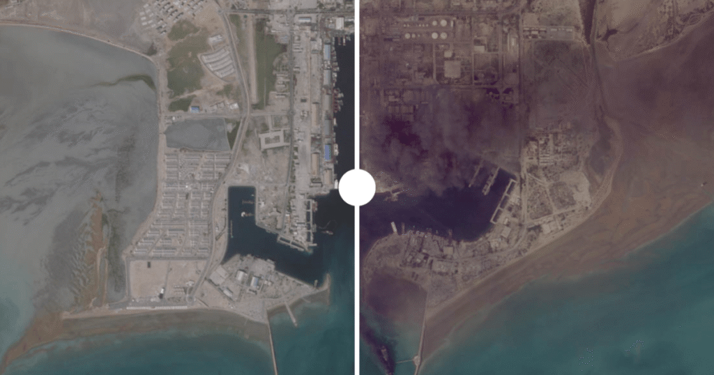
Siri Island, located some 70km (43 miles) from Iran’s southern coast, serves as a vital oil export alternative for several major oil fields.
Satellite imagery from Sentinel-2 taken on April 15, 2026, reveals a huge fire at the island’s oil facilities, with Open Source Unit analysis showing a direct hit to its largest storage tank, which has a capacity of one million barrels, following similar strikes observed at the main Kharg Island oil terminal.
Bandar Abbas, an Iranian port city near the strategic Strait of Hormuz, appears in satellite imagery from Planet Labs and Airbus captured between February 26 and April 1, 2026, and reveals extensive destruction at 11 locations across the complex. Open Source Unit analysis detected severe structural damage to key warehouses and a docked vessel.
Fath Air Base, located near Karaj about 35km (22 miles) west of Tehran, serves as a primary operational hub for the IRGC Aerospace Force, housing key attack helicopter squadrons and drone units.
High-resolution Airbus satellite imagery from April 10, 2026, reveals extensive destruction across the base, with Open Source Unit analysis showing collapsed roofs and severe structural damage at northern hangars and technical facilities, alongside widespread debris and burn marks on the tarmac.
The Bandar Abbas Naval Base, located on the Strait of Hormuz, serves as the primary homeport for the Islamic Republic of Iran Navy (IRIN).
Satellite imagery from Planet Labs captured on March 2 reveals extensive strike damage across the port, with Open Source Unit analysis showing a direct hit to the “IRIS Makran”, which displayed visible fires on its hull and thick smoke rising from its deck, alongside a large blaze affecting key facilities inside the base.
Sites across Lebanon
Naqoura, located in southwestern Lebanon, serves as a highly strategic maritime frontier and headquarters for the United Nations Interim Force in Lebanon (UNIFIL).
Satellite imagery from Planet Labs and Airbus captured between February 18 and April 16 reveals extensive destruction across the area, with Open Source Unit analysis confirming that more than 100 buildings were destroyed.
Bint Jbeil is widely regarded as the symbolic and historical capital of southern Lebanon‘s border region. Satellite imagery from Planet Labs and Airbus captured between February 20 and April 14, 2026, reveals extensive destruction across the town from intense Israeli ground operations and air attacks, with Open Source Unit analysis confirming severe damage to approximately 725 buildings and facilities.
Rachaf, a strategically positioned hilltop town located near the border with Israel in the Bint Jbeil district, serves as a vital residential and agricultural hub overlooking key regional transit routes.
Satellite imagery from Planet Labs and Airbus captured between February 16 and April 16 reveals extensive destruction across the area, with Open Source Unit analysis confirming that entire residential neighbourhoods were levelled to the ground.
Kozah and Beit Lif are neighbouring towns located in southern Lebanon, a few kilometres from the border with Israel.
High-resolution Airbus satellite imagery captured between February 16 and April 16 reveals extensive destruction across both towns, with Open Source Unit analysis confirming heavy damage to historic civil and religious sites, including the St Joseph Church as well as a UNIFIL peacekeeping position.
Sites across the Gulf
Al Udeid Air Base in Qatar, located 30km (19 miles) southwest of Doha, serves as a forward headquarters of US Central Command (CENTCOM).
Satellite imagery from Planet Labs and Airbus captured on April 4 reveals strike damage at the complex, with Open Source Unit analysis detecting structural impact across three distinct locations. The imagery shows the destruction of a logistics operations building, structural damage to a small aircraft shelter, and minor damage to a building inside the Camp Andy housing and support facility.
Kuwait’s Ali Al Salem Air Base serves as a strategic hub for US and coalition forces, providing vital airlift support and military operations across the region.
High-resolution Airbus satellite imagery captured on March 1, 2026, shows damage across nine distinct locations at the base, with Open Source Unit analysis showing the impact concentrated around tent areas and logistics facilities in the northeast and southwest, caused by falling debris from Iranian ballistic missiles intercepted by Kuwaiti air defence systems.
The al-Dhafra airbase, located 32km (20 miles) south of Abu Dhabi, serves as a strategic hub for Western and coalition forces in the Gulf, housing the US Air Force’s 380th Air Expeditionary Wing and operating as a major centre for aerial refuelling, surveillance, and air defence.
European Sentinel and high-resolution Airbus satellite imagery captured on April 7, 2026, reveals new damage at the facility, with Open Source Unit analysis confirming direct hits on several main aircraft hangars inside the base.
Saudi Arabia’s Prince Sultan Air Base, located approximately 80km (50 miles) south of Riyadh, serves as a strategic installation for the Royal Saudi Air Force and a regional operational hub for US military forces.
Sentinel-2 satellite imagery captured on March 29 reveals damage at the expansive base following an Iranian missile and drone attack, with Open Source Unit analysis confirming destruction across at least three locations, including charring on the tarmac, structural damage to an adjacent building, and a direct strike impact on one of the main runways leading to the aircraft parking area.
The US Fifth Fleet Headquarters, located at the Mina Salman naval facility in Manama, Bahrain, serves as the premier strategic command centre for US naval operations across the Middle East.
Planet Labs satellite imagery captured on March 1 reveals extensive structural damage at the highly critical naval command complex following Iranian strikes, with Open Source Unit analysis detecting direct hits to multiple radar domes, along with widespread damage impacting several vital facilities and buildings within the base.